Blog

Navigating Flood Planning Controls in New South Wales: Key Overlays and What They Mean for Development Flooding is a common natural hazard in many parts of New South Wales (NSW), and local councils, along with the NSW government, have implemented specific planning controls to manage flood risk. If you’re looking to develop or build in NSW, understanding the key flood-related overlays and controls is crucial to ensure a compliant, resilient project and avoid costly setbacks. Key Flood Planning Controls in NSW Flood planning controls in NSW are embedded in local council planning schemes and influenced by both Local Environmental Plans (LEPs) and Development Control Plans (DCPs). Together with state guidelines, such as the NSW Flood Prone Land Policy and Floodplain Development Manual, these planning documents define flood risk areas and outline requirements to manage development safely within them. Here’s a closer look at the primary flood-related controls and floodplain definitions that developers and landowners should be aware of: Flood Planning Area (FPA) Purpose: The FPA identifies land that lies below the Flood Planning Level (FPL) . The FPL is a combination of the flood level from the Defined Flood Event (DFE) and an appropriate level of freeboard selected for flood risk management purposes. For assessing development in New South Wales the defined flood event is typically the 1% AEP event although this is not always the case. The FPA is a planning control which ensures that the underlying flood risk in those locations is appropriately managed. Requirements: Developments within the FPA must meet specific elevation and design requirements to minimise flood impacts. Plans may need to show how they accommodate flood flow and protect buildings, contents and occupants. Implications for Development: Early consideration of flood-resilient design is essential in FPA areas, as it can influence building placement, floor elevation, and materials. Floodway Areas Purpose: Floodway Areas are areas of land critical for the conveyance of floodwaters, particularly vulnerable to high-velocity or deep flood flows. Development is strictly controlled in these areas to ensure water can flow safely during a flood. Requirements: New development in Floodway Areas is highly restricted. Any proposed construction must demonstrate that it won’t hinder water flow or increase flood risk to surrounding areas. Implications for Development: Development in Floodway Areas is often limited or prohibited, and proposals may require detailed hydraulic analysis to demonstrate no adverse impact on flood behavior. High Hazard Areas Purpose: Similar to Floodway Areas, High Hazard Areas within the floodplain are locations where floodwaters pose a significant threat to life and property due to deep or fast-moving waters. These areas require careful consideration when planning any development. Requirements : Development in High Hazard Areas is typically discouraged. Where development is allowed, stringent conditions apply, including elevated construction, flood-resistant materials, and emergency evacuation plans. Flood modelling is also likely required to demonstrate no adverse impacts to other properties. Implications for Development: As with Floodway Areas, High Hazard designations can make development costly or unviable, as it may necessitate extensive modifications to meet safety standards. LEPs and DCPs: How They Guide Flood Risk Management Both Local Environmental Plans (LEPs) and Development Control Plans (DCPs) play a central role in flood risk management in NSW. LEPs outline zoning and land use controls, defining flood-prone land boundaries and providing a high-level framework for what can and cannot be built in flood-affected areas. DCPs provide more detailed guidance, offering specific development standards for construction in flood-prone zones, such as building elevations, materials, and drainage requirements. Together, these documents establish the guidelines that developers must adhere to for safe and compliant developments in flood-prone areas. Why Consider Flood Controls Early? Assessing flood planning controls early in the development process is crucial for several reasons: Avoid Costly Redesigns: Recognizing flood controls early can prevent expensive redesigns down the line. Early engagement allows developers to design with flood risks in mind from the start, avoiding costly last-minute changes. Ensure Regulatory Compliance: Development in flood-prone areas is subject to strict controls for public safety and environmental protection. Understanding these controls upfront helps streamline the approval process and reduce delays. Safeguard Property and Life: Incorporating flood resilience into design isn’t just about meeting regulations – it’s about ensuring the long-term safety of occupants. Addressing flood risks early on can make properties more resilient to flooding events, protecting residents and reducing future damages. Support Community Flood Resilience: Well-planned developments contribute to broader community flood resilience. By respecting floodways and implementing effective flood mitigation measures, developments help minimize flood impact on surrounding areas, benefiting the entire community. Check Your Property’s Flood Designation If you’re considering a project in NSW, there are a number of sources to check flood designations for your property. Most local councils provide online tools or resources to identify areas affected by flood controls. Additionally, property reports are often available through council websites or NSW’s Planning Portal , which provides further insight into flood risks, LEPs, DCPs, and applicable controls. Engage Floodplain Management Experts Early in The Process Flood planning controls and requirements in LEPs and DCPs can be complex, and interpreting their implications for a specific site often requires specialist knowledge. At Cumulus Engineering, we’re experienced in navigating NSW’s flood risk framework, helping clients understand site-specific requirements and mitigate risks. Getting us involved early can make all the difference in planning a safe, compliant, and resilient development, avoiding costly redesigns and ensuring peace of mind. In Summary Flooding is a significant challenge in many parts of New South Wales, and understanding the state’s flood-related planning controls is critical for compliant and resilient development. These controls, outlined in Local Environmental Plans (LEPs), Development Control Plans (DCPs), and state policies, help manage flood risks by identifying areas like Flood Planning Areas, Floodway Areas, and High Hazard Areas, each with specific considerations and requirements. Early consideration of flood controls can prevent costly redesigns, streamline approvals, and enhance safety. Engaging experts like Cumulus Engineering early in the process ensures tailored advice, helping you navigate regulations, minimize risks, and contribute to community flood resilience.

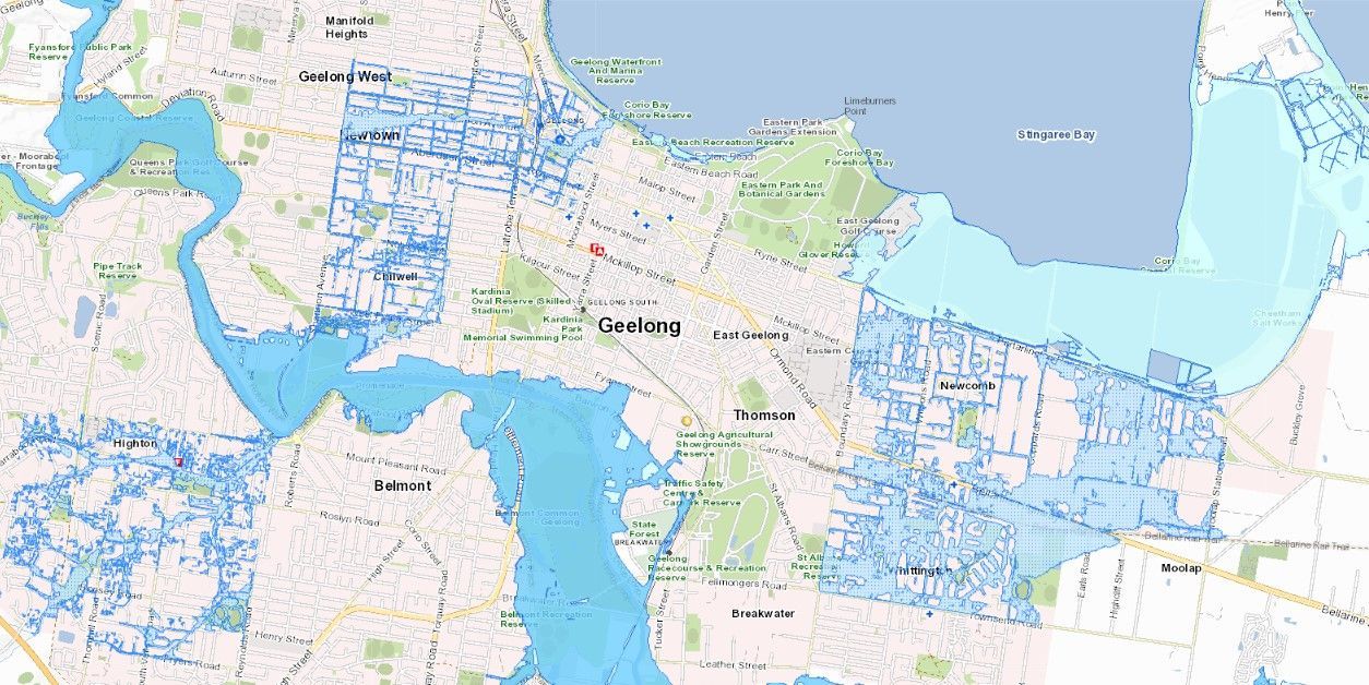
Flooding is a significant natural hazard, and Victoria’s planning scheme includes specific overlays designed to manage and mitigate flood risks. If you’re involved in property development or planning or even general land ownership, understanding these overlays – the Land Subject to Inundation Overlay (LSIO), the Floodway Overlay (FO), and the Special Building Overlay (SBO) – is crucial to ensure a smoother process and avoid costly delays or modifications. What are Flood Planning Overlays? Flood planning overlays are part of Victoria’s planning framework, embedded in local planning schemes to identify areas vulnerable to flood risks. These overlays establish requirements and considerations to reduce flood-related risks to property, infrastructure, and communities. Here’s a breakdown of the three main overlays: Land Subject to Inundation Overlay (LSIO) Purpose: The LSIO covers areas that may experience flooding in a defined flood event - typically the 1% AEP flood event in Victoria. It highlights regions land affected by flooding associated with waterways and open drainage systems. Such areas are commonly known as floodplains. Requirements: Developments in LSIO areas typically need to account for flood impacts, ensuring buildings and occupants are adequately protected. Plans might need to show how they manage floodwaters or limit property damage in flood events. Implications for Development: The LSIO requires early consideration of flood-resistant design and may influence building and lot elevations and materials. 2. Floodway Overlay (FO) Purpose: The FO represents areas within the primary flood path where water moves at high velocity or at significant depths during a flood. These zones are considered essential floodways, which need to remain clear to allow the safe passage of water during significant events. Requirements: Development in FO areas is more restricted, as development may impede floodwater flow or result in adverse impacts on adjoining areas. Development potential in these areas is limited and any works must demonstrate that they won’t compromise floodway function or increase flood risk to other properties or key infrastructure. Implications for Development: This overlay usually prohibits or heavily restricts construction in these areas, which may make certain developments unviable. Detailed hydraulic analysis may be required for any works proposed in these areas. 3. Special Building Overlay (SBO) Purpose: The SBO applies to areas affected by local overland flows, often related to urban stormwater flooding. This overlay addresses risks from stormwater flooding, particularly in areas with limited drainage capacity during heavy rainfall events. Requirements: Developments in SBO areas must often include drainage solutions or raised floor levels to protect structures and inhabitants from flooding. Planning permits must consider measures to redirect or control water flows. Implications for Development: The SBO typically impacts urban areas and similar to LSIO, requires appropriate consideration in the site design. This may influence the site layout and floor elevations to ensure overland flow is not obstructed and buildings are designed appropriately. Flood modelling may also be required to demonstrate no adverse impacts to off-site properties and infrastructure. Why Consider Flood Planning Overlays Early? Flood planning overlays should be assessed early in the development process for several reasons: Avoid Costly Redesigns: Recognising flood overlays early on can prevent expensive modifications later. It enables developers to design with flood risk in mind from the outset, reducing the likelihood of needing costly redesigns or worst case - retrofits. Ensure Regulatory Compliance: Development in flood-prone areas is subject to strict planning controls to protect communities and the environment. Early consideration ensures compliance with local planning schemes, helping to streamline the approval process. Protect Property and Life: Integrating flood resilience into design isn’t just about meeting regulations – it’s about ensuring safety for future occupants. Planning with flood overlays in mind helps create properties better equipped to withstand flooding, protecting residents and reducing potential flood damage. Enhance Community Resilience: Well-planned developments contribute to broader community flood resilience. By respecting floodways and managing stormwater flow, developments can help minimise the impact of flooding on surrounding areas, benefiting the entire community. Check Your Property’s Overlays on VicPlan Before diving into any development, it’s easy to check your property’s flood overlays. The VicPlan website allows you to view zoning information, including flood overlays, and download a detailed property report. This tool helps identify potential flood-related considerations early on, providing a clearer picture of any planning restrictions and requirements tied to the LSIO, FO, or SBO. Get Expert Guidance with Cumulus Engineering Understanding flood overlays and their implications for your site can be complex. Getting specialists like Cumulus Engineering involved early can help you interpret these overlays, understand site-specific requirements, and navigate any constraints early in a project. With experience in flood risk management and development planning, Cumulus can offer tailored advice to ensure your project is both compliant and resilient, saving you time, reducing costs, and providing confidence in flood-prone areas. In Summary The LSIO, FO, and SBO are essential tools in Victoria’s planning scheme to identify and manage flood risks. Early consideration of these overlays in development planning is essential for compliance, safety, and sustainability. By working with these guidelines, utilising resources like VicPlan, and involving specialists like Cumulus Engineering, developers can contribute to safer, more resilient communities and reduce the long-term impacts of flooding on both property and people.

